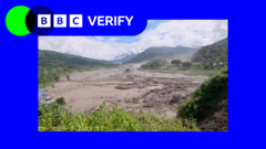
The water does not arrive as a polite rising of the riverbanks. It comes down the valley as a roaring, graphite-colored wall of mud, shattered pine trunks, and pulverized stone, displacing air with enough violence to snap steel bridges like dry twigs. When a catastrophic flash flood tears through the river systems of Nepal and Tibet, the standard media autopsy follows a predictable script. Commentators point lazily to the seasonal monsoon rains. They blame excessive downpours and move on.
That explanation is an intellectual cop-out. It hides the mechanical reality of what is actually happening at the roof of the world.
Heavy rainfall is only the match thrown into a room already soaked in gasoline. The real driver behind the deadly flooding in Nepal is a structural transformation of the cryosphere, compounded by decades of reckless infrastructure placement and unchecked valley urbanization. To understand why villages are being wiped out overnight, we have to look past the superficial narrative of seasonal weather and examine the terrifying physics of a warming mountain range.
The Shattered Bedrock of High Asia
Think of the high Himalayas not as solid rock, but as unstable masonry. For millennia, massive glaciers and underground permafrost acted as a cryogenic cement, holding shattered bedrock and steep moraine walls tightly together in a frozen grip. Global heating is melting that ancient glue.
When average temperatures climb faster at high altitudes than across the rest of the planet—a phenomenon known as elevation-dependent warming—the ice filling the mountain joints turns to water. Long before a drop of monsoon rain falls, the internal plumbing of these massive peaks is compromised. Crevasses fill with meltwater. Subsurface ice packs lose their adhesion to steep rock faces.
A prime example occurred when a colossal rock-and-ice avalanche broke free from a high-altitude slope, crashing down with enough kinetic energy to register on seismic monitors as an earthquake. This sudden collapse dumped millions of tons of debris directly into a narrow river gorge, creating an unstable natural dam. When that temporary barrier inevitably blew out minutes later, it unleashed a tsunami-like pulse of water that devastated everything in its path downstream.
Rain does not cause that initial structural failure. Gravity, acting on heat-weakened ice, pulls the trigger.
The Downstream Trap of Rapid Development
While the top of the world is unravelling, the bottom of the valleys is filling up with concrete. Nepal is caught in a desperate economic squeeze. With limited flat terrain available for a growing population, human settlement, roads, and critical hydropower projects are jammed tightly into narrow river corridors and historic floodplains.
Roads cut into steep mountain flanks destabilize the toes of already fragile slopes, ensuring that every heavy shower triggers secondary landslides that choke river channels. Hydropower installations, vital for the region's energy independence, are routinely sited right in the crosshairs of potential high-energy debris flows.
Consider the mathematics of a standard narrow valley. When a river channel is constricted by poorly planned embankments, human encroachment, and dumped construction waste, it loses its hydraulic capacity. A volume of water that safely passed through a wide, natural gorge twenty years ago will now overtop modern barriers with ease.
Deforestation compounds this vulnerability with brutal efficiency. Entire hillsides stripped of native forest cover can no longer anchor surface soils against torrential downpours. The soil liquefies, slides into the main artery, and turns an ordinary river into a battering ram of slurry.
The Failure of Transboundary Early Warning
Even if we accept that the mountains are structurally compromised and the valleys are overpopulated, a glaring question remains. Why are people still dying by the hundreds?
The answer lies in a fractured bureaucratic and geopolitical landscape. Many of the most catastrophic triggers—such as glacial lake outbursts or high-altitude ice collapses—frequently originate across the northern border in Tibet, far beyond the direct observation network of Nepal’s meteorological department.
Water does not respect international borders, but data sharing certainly does. Early warning systems across the Hindu Kush Himalaya remain fragmented, underfunded, and heavily reliant on manual alerts rather than automated, real-time sensor networks. By the time a sudden surge in river volume is visually spotted by downstream villagers, they have minutes—sometimes seconds—to escape. Sirens cannot save a community if they sound only after the wave has already broken the bridge.
Communities in the southern Terai plains face a different flavor of the same crisis. There, the threat is slow-onset inundation and massive riverbank erosion caused by unregulated embankment building upstream. Each country tries to protect its own territory by pushing water toward its neighbor, creating an uncoordinated cycle of hydraulic brinkmanship that leaves rural populations entirely exposed.
Moving Past the Monsoon Myth
As global temperatures continue to edge toward dangerous thresholds, dismissing these disasters as mere products of the seasonal monsoon is no longer just inaccurate—it is dangerous. It absolves planners from rethinking where they build roads, where they anchor power grids, and how they manage transboundary river basins.
The physical reality of the third pole is shifting beneath our feet. Until disaster management policy catches up with the brutal mechanics of a melting cryosphere, the rivers of Nepal will keep rewriting the map on their own terms.