The weaponization of the electromagnetic spectrum has transitioned from a specialized electronic warfare capability to a baseline atmospheric condition in the Middle East. Global Navigation Satellite Systems (GNSS), primarily GPS, are no longer reliable utilities in the Levant or the Persian Gulf. This is not merely "jamming" in the colloquial sense of a blocked signal; it is a sophisticated re-engineering of regional geography through signal manipulation. Understanding the current crisis requires a transition from viewing GPS as a "map" to viewing it as a vulnerable time-of-flight calculation susceptible to two distinct vectors: power-based suppression and data-based deception.
The Physics of Signal Asymmetry
To analyze the degradation of regional navigation, one must first quantify the inherent weakness of GNSS architecture. GPS satellites orbit at approximately 20,200 kilometers. By the time a signal reaches a receiver on Earth, its power level is roughly -160 dBW—equivalent to viewing a 25-watt lightbulb from 10,000 miles away. This extreme path loss creates a fundamental asymmetry: a low-cost, ground-based transmitter can easily overwhelm the satellite signal with several orders of magnitude more power. In related developments, take a look at: The Hollow Classroom and the Cost of a Digital Savior.
The current "invisible battle" operates across three functional layers of interference:
- Brute Force Noise (Jamming): The transmitter emits high-power radio frequency (RF) noise on the L1 (1575.42 MHz) and L2 (1227.60 MHz) bands. This raises the noise floor until the receiver can no longer extract the navigation message from the background static.
- Symmetric Spooking (Meaconing): The intercepting party records valid GNSS signals and rebroadcasts them with a delay. This confuses the receiver’s timing calculations, leading to inaccurate position fixes or a complete inability to maintain a "lock."
- Coherent Manipulation (Spoofing): This is the most advanced vector. The attacker generates a false signal that mimics a legitimate satellite constellation but provides false coordinates. A receiver "captures" this stronger, false signal and reports a location that may be hundreds of miles from the actual device.
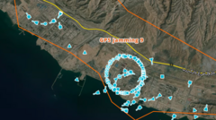
The Geographic Displacement of Tel Aviv and Beirut
In early 2024, commercial flight crews and smartphone users in Israel and Lebanon began reporting their location as Cairo International Airport or Beirut-Rafic Hariri International Airport while physically located in Tel Aviv or Haifa. This is not a technical glitch; it is a defensive protocol. The Verge has analyzed this important topic in great detail.
By spoofing coordinates to major airports, state actors achieve a specific tactical objective: the neutralization of low-cost, GNSS-guided munitions. Many commercial-grade drones and precision-guided missiles are programmed with "no-fly zones" (NFZs) hardcoded into their firmware to prevent them from entering sensitive airspace like international airports. If a missile’s receiver believes it is suddenly inside Cairo Airport, the onboard logic may trigger an immediate engine cutoff or a forced landing.
This creates a Geofencing Paradox. The defender uses the attacker's own safety software against them. However, this creates massive externalities for civilian infrastructure. Logistics networks, ride-sharing apps, and emergency services—all dependent on the L1 band—become non-functional, causing an unquantified but significant "friction tax" on the local economy.
The Strategic Cost Function of Electronic Warfare
Electronic Warfare (EW) is often viewed through the lens of capability, but it is better understood through the lens of Cost-Exchange Ratios.
- Attacker Cost: Utilizing a $500 drone with a GPS-dependent flight controller.
- Defender Cost (Kinetic): Utilizing a $2 million interceptor missile.
- Defender Cost (Electronic): Utilizing a high-output jammer that costs pennies in electricity but creates millions in collateral economic disruption.
The proliferation of GPS interference in the Middle East suggests that regional powers have calculated that the economic friction of civilian GPS failure is lower than the kinetic cost of intercepting mass-produced loitering munitions. We are seeing a shift where the "Iron Dome" of the future is not a missile battery, but a localized "black hole" in the electromagnetic spectrum.
Vulnerabilities in Multi-Constellation Receivers
A common misconception is that switching from the American GPS to the European Galileo, Russian GLONASS, or Chinese BeiDou provides a fallback. Modern GNSS chips are "multi-constellation," meaning they aggregate signals from all available satellites to increase precision.
The bottleneck is the antenna and the front-end processor. If a jammer floods the 1.2 GHz to 1.6 GHz range, it saturates the receiver's Low Noise Amplifier (LNA). Once the LNA is saturated, the receiver is "blinded" across all constellations regardless of which specific satellite system it intends to use. Advanced military units utilize CRPA (Controlled Reception Pattern Antennas). These systems use multiple antenna elements to "steer" a null toward the source of the jamming, effectively ignoring the interference. The civilian sector, however, lacks the physical space and budget for CRPA integration, leaving the entire commercial aviation and maritime industry exposed.
Maritime Implications and the Ghost Fleet Effect
In the Eastern Mediterranean and the Red Sea, the impact of GNSS interference extends to the Automatic Identification System (AIS). AIS is the primary method for ships to broadcast their position to avoid collisions. When GPS is spoofed, AIS data becomes fraudulent.
This creates a "Ghost Fleet" environment. Ships appearing to be in one corridor may be miles away, or they may disappear from digital tracking entirely to avoid targeting by non-state actors using open-source intelligence (OSINT). The breakdown of AIS reliability forces a return to legacy navigation: radar-based pilotage and visual station-keeping. The systemic risk here is a massive increase in the probability of maritime accidents in high-traffic chokepoints like the Suez Canal or the Strait of Hormuz.
The Shift to Alternative Navigation (ALTNAV)
Because GNSS is now a contested domain, we are observing a forced evolution toward ALTNAV technologies. These systems aim to provide PNT (Positioning, Navigation, and Timing) without any reliance on external satellite signals.
- Inertial Navigation Systems (INS): Using high-end accelerometers and gyroscopes to track movement from a known starting point. High-end "Strategic Grade" INS can maintain accuracy for hours, but "Tactical Grade" sensors found in smaller drones "drift" significantly within minutes.
- Terrain Contour Matching (TERCOM): Using onboard cameras or LIDAR to compare the ground below to a pre-loaded 3D map. This is immune to RF jamming but fails over open water or featureless desert.
- Signals of Opportunity (SoOP): Using the known locations of radio towers, Starlink satellites, or even TV broadcasts to triangulate a position.
- Quantum Positioning: The theoretical end-state of navigation, using cold-atom interferometry to detect minute changes in gravity and motion with zero drift. This remains in the laboratory phase but represents the only long-term "un-jammable" solution.
Logical Failures in Current Counter-Measures
The primary strategy for addressing GNSS interference today is reactive. When jamming is detected, pilots switch to manual control or VOR (VHF Omnidirectional Range) beacons. However, the VOR infrastructure has been significantly decommissioned over the last two decades in favor of GPS. This "Infrastructure Debt" means that as the Middle East's GPS reliability hits zero, the backup systems are often too sparse or poorly maintained to handle the traffic density.
Furthermore, the assumption that spoofing can be "filtered" by software is flawed. If a spoofer is sophisticated enough to provide a signal that is phase-aligned with the legitimate constellation, there is no mathematical way for a standard single-antenna receiver to distinguish the two.
Strategic Requirement for Sovereign Timing
While navigation is the most visible victim, the more dangerous vulnerability is Timing. The global financial system, cellular networks (5G), and power grids rely on the nanosecond-accurate atomic clocks aboard GPS satellites to synchronize operations.
If a regional actor successfully jams GPS timing signals over a major financial hub like Dubai or Riyadh for an extended period, the "handover" between cell towers will fail, and high-frequency trading platforms will de-sync. The Middle East is currently a laboratory for "Total Spectrum Denial," where the goal is not just to miss-guide a missile, but to desynchronize the digital heart of a nation-state.
The Final Strategic Play
The transition of the Middle East into a GNSS-denied environment is permanent. Organizations operating in this theater must immediately move beyond "GPS-plus-backup" architectures and adopt a Zero-Trust Positioning framework.
This requires:
- Mandatory INS Integration: Every autonomous or semi-autonomous asset must possess an Inertial Navigation System capable of maintaining a <100m circular error probable (CEP) for at least 30 minutes without a GNSS fix.
- Optical Verification: Implementation of "Vision-Based Navigation" (VBN) as the primary verification layer for GNSS data. If the GPS says "Beirut" but the camera sees "Coastal Highway," the system must autonomously flag a spoofing event.
- Regional Ground-Based Augmentation: State actors must reinvest in high-power eLoran (enhanced Long Range Navigation) or similar terrestrial, low-frequency systems that provide a high-power, difficult-to-jam alternative for timing and positioning.
The era of "free" and "always-on" satellite data is over in contested zones. The competitive advantage will belong to those who treat the electromagnetic spectrum as a hostile environment rather than a transparent medium.