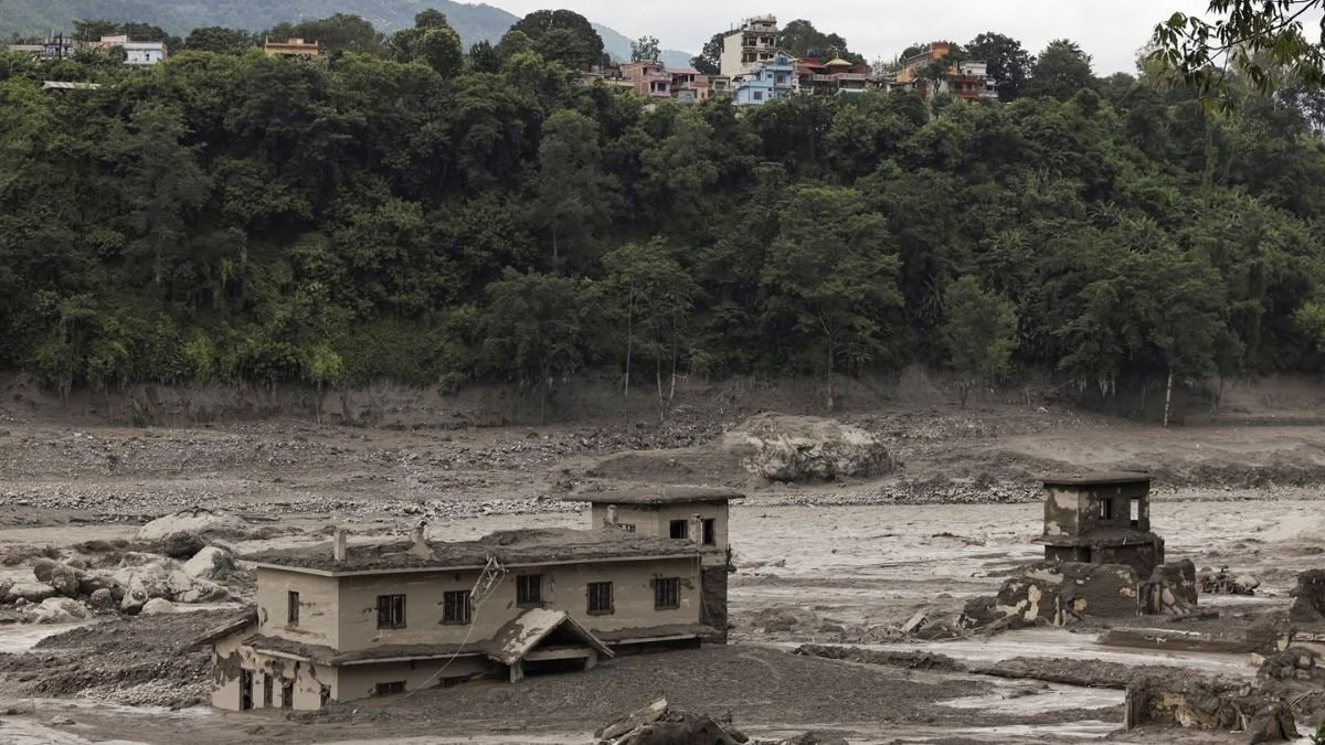
Hydrological anomalies in high-altitude mountain basins operate under physics distinct from standard meteorological inundations. When a nine-metre water level spike occurs within a thirty-minute window along the Trishuli river system, standard rainfall metrics fail to explain the phenomenon. The flash flood that devastated Nepal's northern Rasuwa district on August 26 exemplifies a severe cryospheric hazard cascade, driven by a sequence of geophysical triggers rather than conventional monsoon runoff. Deconstructing this event requires an examination of how seismic energy, ice avalanches, and natural dam mechanics interact within fragile high-altitude geomorphic environments.
The Kinematics of Mountain Geohazards
The primary vector of the Rasuwa catastrophe centered on the Lhende Khola, a steep tributary of the Bhote Koshi river system running along the Nepal-Tibet border. At 8:37 AM local time, the United States Geological Survey recorded a magnitude 4.4 earthquake originating approximately forty-seven kilometres north of Gosainkunda in Tibetan territory. Concurrently, seismic stations and local observations noted unusual activity that preceded an ice-and-rock avalanche crashing into the narrow river valley.
In steep terrain characterized by slopes exceeding thirty degrees and highly weathered lithology, a seismic impulse acts as a direct destabilization mechanism. The energy release breaks the shear strength holding high-altitude hanging glaciers and permafrost-bound scree slopes in place. When millions of metric tons of ice and rock detach, two destructive mechanisms occur simultaneously:
- Displacement Surge: The sheer mass of the avalanche impacting the narrow river channel instantly displaces existing water, creating an immediate, debris-choked kinetic wave.
- Natural Dam Formation: The residual debris mass lodges within constricted canyon bottlenecks, creating an unstable landslide dam that impedes upstream flow.
Water accumulation behind a newly formed debris barrier does not scale linearly. Hydrostatic pressure increases exponentially relative to the volume of trapped water. Once the barrier's structural integrity fails—whether through seepage, overtopping, or internal erosion—the impounded volume releases instantaneously. This dam-break wave transforms into a hyper-concentrated debris flow, scouring riverbanks, destroying hydropower infrastructure, and accelerating down steep gradients with devastating momentum.
Evaluating Competing Hypotheses
Attributing high-mountain flash floods requires parsing multiple interacting failure modes. Analysts examining the Rasuwa event must weigh three primary hypotheses: a seismic-triggered ice avalanche, a glacial lake outburst flood, or a pure meteorological cloudburst.
Local meteorological data from Rasuwa district confirmed that intense local rainfall was absent at the time of the initial surge, eliminating standard precipitation-driven runoff models. This leaves cryospheric failures as the dominant physical drivers.
Glacial lake outburst floods occur when moraine dams holding alpine meltwater breach. While the region contains multiple large glacial lakes and experienced a similar event on July 8, 2025, satellite telemetry and field assessments pointed primarily toward an avalanche-induced river blockage on the Lhende Khola. The temporal proximity of the 4.4 magnitude tremor strongly implicates seismic shaking as the triggering catalyst for slope failure, though the exact transition from tremor to mass movement remains a subject of ongoing cryoseismic research.
This multi-variable causality demonstrates why single-cause explanations fail in Himalayan risk management. A minor earthquake in a stable tectonic setting produces minimal surface damage; the same magnitude 4.4 tremor in an over-steepened, glacially carved valley triggers a cascade of secondary mass movements.
Structural Vulnerabilities in High-Altitude Infrastructure
The human and economic cost of the Rasuwa disaster—spanning hundreds of missing individuals, washed-out transport links, and hundreds of megawatts of compromised hydropower capacity—highlights the friction between rapid regional development and high-risk geomorphology.
The economic model of Himalayan hydropower development often prioritizes run-of-the-river installations located in narrow gorges. These locations optimize hydraulic head and energy generation potential but place physical assets directly within active transport zones for rockfalls, avalanches, and debris flows. When an upstream blockage releases, the infrastructure acts as a primary energy dissipator, absorbing the full kinetic force of the water-rock mixture.
Furthermore, transboundary river governance complicates early warning efficiency. Because watersheds like the Bhote Koshi-Sun Koshi basin originate in the Tibetan Autonomous Region of China before flowing into Nepal, upstream disruptions occur beyond the direct monitoring perimeter of downstream national agencies. Communication latency between border observation posts and downstream population centres creates a critical window of vulnerability, limiting the time available for evacuation along the Trishuli corridor.
Mitigating Cryospheric Risk Cascades
Managing future exposure in high-risk districts requires a shift from reactive disaster response to predictive geomorphological monitoring. Traditional flood warning systems rely on river gauge sensors that measure water level rises. In cases of sudden dam-break waves or ice avalanche impacts, river gauges provide seconds of warning—insufficient for effective evacuation along steep valley floors.
Effective structural resilience demands the deployment of upstream acoustic flow monitors, high-resolution satellite radar interferometry to detect slope creep before failure, and seismic sensor arrays capable of distinguishing between tectonic tremors and mass-wasting events. Infrastructure placement must also incorporate dynamic flood-routing models that account for potential artificial damming events rather than relying purely on historical peak monsoon discharge rates.
Future hazard mitigation in regions like Rasuwa depends on treating the entire cryospheric corridor as a single integrated system. Where seismic thresholds intersect with unstable glacial and permafrost environments, sudden catastrophic releases remain a permanent baseline risk, requiring continuous monitoring and strict spatial planning away from active debris tracks.