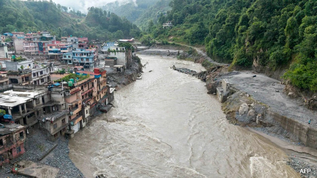
At least 469 people are dead, more than 1,500 remain missing across Nepal and Tibet, and thirty-three British nationals are among the unaccounted for following a catastrophic glacial collapse near the border. The numbers are staggering, but they represent only the immediate body count of a much larger, systemic failure in high-altitude environmental monitoring.
When a massive wall of mud, rock, and water tore down the Rasuwa district and swept across the Nepal-Tibet frontier, mainstream outlets immediately framed the catastrophe as an unpredictable act of nature. They pointed to the sheer wall of water, the destroyed bridges, and the stranded pilgrims heading toward Mount Kailash. They warned breathlessly of a second flood wave as upstream barrier lakes strain against capacity.
Yet focusing solely on the impending secondary deluge misses the structural reality of what is happening along the roof of the world. This was not a random cloudburst. It was a predictable consequence of accelerated glacial melting, inadequate transboundary data sharing, and a tourism infrastructure that continues to push deeper into high-risk alpine zones without modern early-warning architecture.
The Anatomy of a High-Altitude Collapse
Satellite analysis indicates that the disaster began when bedrock beneath a high-altitude glacier failed, sending a massive ice-and-rock avalanche into the valleys below. When this debris mixed with melted glacial water, it transformed into a high-density debris flow—a hyper-concentrated slurry that moves with the destructive force of a freight train and leaves almost no reaction time for communities downstream.
The geography of the Himalayas makes these regions exceptionally vulnerable. Steep gradients mean that water and debris accelerate rapidly, turning small mountain streams into lethal torrents within minutes. Tour operators working along the popular trekking and pilgrimage routes to Mount Kailash and Gosaikunda Lake face a landscape that is fundamentally rewriting itself.
The climate physics driving these events are well-documented. As global temperatures rise, high-mountain Asia warms at rates significantly higher than the global average. Permafrost thaws, destabilizing the rock walls that hold glacial lakes and mountain slopes in place. When these natural dams fail, the resulting outburst floods unleash millions of cubic meters of water into narrow river gorges.
Despite decades of warnings from glaciologists and climate scientists, disaster response frameworks in the region remain stubbornly reactive. Search and rescue teams are currently deploying helicopters to pluck survivors from isolated pockets and search dark tunnels at hydroelectric projects like the Upper Trishuli-1 site. But flying helicopters into narrow gorges choked with monsoon clouds is a desperate measure, deployed only after the damage is done.
The Transboundary Blind Spot
One of the most glaring vulnerabilities exposed by this crisis is the breakdown in communication across the international border. The Himalayas do not respect geopolitical boundaries, but emergency response systems do.
When a glacial lake outburst flood or a massive landslide occurs upstream in Tibet, the water crosses into Nepal within hours, sometimes minutes. Real-time hydrological data sharing between China, India, and Nepal remains fragmented and overly bureaucratic. By the time automated alerts or official warnings traverse diplomatic channels, the muddy wall of water has already breached border immigration checkpoints and wiped out settlements.
Tour operators and local guides are left operating in a vacuum. Companies like Alpine Eco Trek and various local agencies maintain radio contact with trekking groups until communication lines simply go dark. The loss of contact with dozens of foreign nationals—including citizens from Britain, the United States, Australia, Canada, and India—underscores a dangerous information asymmetry. Tourists and pilgrims are walking into zones where local authorities lack the advanced sensors needed to detect upstream swelling before it reaches inhabited valleys.
The Economics of Alpine Risk
Tourism is a vital pillar of Nepal’s economy, injecting critical foreign capital into remote mountain districts. The autumn trekking season draws thousands of international visitors eager to experience the high passes.
This economic imperative creates a powerful incentive to downplay systemic risks. Closing high-altitude borders or halting lucrative pilgrimages during peak monsoon and shoulder seasons invites immense financial pushback. Consequently, safety protocols often rely on historical weather patterns that no longer apply in an era of rapid climate destabilization.
Infrastructure development compounds the danger. Hydroelectric projects, road expansions, and bridge construction are carving deep into unstable mountain slopes to meet energy and transportation demands. While these projects are essential for regional modernization, they frequently alter local hydrology and load fragile slopes with heavy spoil material. When a flash flood hits, this loose construction debris multiplies the destructive mass of the water, turning an ordinary river swell into a landscape-altering disaster.
Preparing for the Next Inevitable Wave
As rescue operations grind forward and international aid pledges roll in—including an initial five million pound commitment from the British government—attention inevitably turns to the threat of overflowing barrier lakes upstream. Engineers and military personnel are monitoring these natural dams, knowing that a secondary breach could undo ongoing recovery efforts in an instant.
Fixing this systemic crisis requires moving past emergency fundraising appeals and addressing the root causes of high-altitude vulnerability. Governments across South Asia must invest in automated, real-time sensor networks along major glacial river basins. Transboundary data agreements must be depoliticized, allowing hydrological data to flow instantly across borders regardless of diplomatic friction.
Furthermore, tour operators and local authorities need stricter zoning laws for infrastructure and expedition routes. Allowing thousands of trekkers and pilgrims into narrow gorges during periods of high glacial instability is a gamble that the mountains will eventually collect on.
The search parties scouring the debris fields of Rasuwa and Tibet are dealing with the immediate tragedy of lost lives. Unless regional policy shifts from reactive rescue to proactive, science-driven hazard mitigation, these recovery operations will become a recurring feature of life in the shadow of the world's highest peaks.